


Land topographical surveys are a cornerstone of successful construction, engineering, and land development projects. Whether you’re planning a residential build, a commercial site, or even a public infrastructure project, a clear understanding of the land you’re working on is crucial. This is where a topographical survey becomes an essential tool.
Topographical surveys map the natural and man-made features of a specific piece of land. They provide crucial details such as elevation changes, existing structures, surface contours, vegetation, drainage systems, and utility lines. This article will explain everything you need to know about land topographical surveys—from their purpose and process to their benefits and when you need one.
What Is a Land Topographical Survey?
A Land topographical surveyors surveys is a detailed examination and mapping of the physical features of a land parcel. Unlike a basic property boundary survey, which simply defines the legal edges of a plot, a topographical survey looks at everything on and sometimes beneath the surface of the land.
Surveyors collect data that reflects the contours of the terrain, elevations, man-made structures (like buildings, roads, fences), natural features (such as trees, rivers, slopes), and infrastructure (like underground utilities). The result is a comprehensive topographical map that visually represents the landscape’s three-dimensional features.
This map is used in planning, design, construction, renovation, and environmental assessments. It serves as a fundamental reference for everyone involved in the project, from architects and engineers to contractors and local authorities.
Why Topographical Surveys Are So Important
Topographical surveys play a critical role in reducing guesswork and avoiding expensive errors during development. They provide precise data that influences:
-
Site design: Architects and planners can design structures that work with the terrain, rather than against it.
-
Engineering decisions: Civil engineers use topographical data to plan grading, drainage systems, and utility layouts.
-
Cost estimation: Understanding the land helps calculate earthwork, material needs, and access logistics.
-
Permit applications: Most planning departments require topographical data before issuing development permits.
-
Legal protection: Surveys document land features and boundaries, helping avoid future disputes.
Without a proper topographical survey, developers risk running into unforeseen problems like uneven ground, improper drainage, encroachments, or costly rework due to incorrect assumptions about the site.
Key Features Included in a Topographical Survey
A comprehensive land topographical survey includes several types of information:
Terrain and Elevation
Surveyors measure elevation at various points to identify slopes, dips, and level areas. This helps in determining how the land needs to be shaped or leveled for construction and landscaping.
Natural Features
Trees, water bodies, vegetation types, rock outcrops, and other natural features are recorded. These might need to be preserved, relocated, or factored into environmental assessments.
Man-Made Structures
Any existing buildings, walls, utility poles, fences, and pavement are mapped out. Even small structures like sheds or walkways are usually documented if they affect the development.
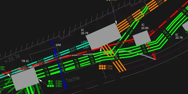
Utilities and Infrastructure
Surveyors try to locate visible and known underground utilities such as sewer lines, water pipes, gas lines, and electrical conduits. Accurate knowledge of these features is essential for safety and planning.
Boundary Information
While not always the primary focus, many topographical surveys also incorporate boundary lines or are conducted alongside boundary surveys for full site clarity.
When Do You Need a Topographical Survey?
There are several situations where a land topographical survey is recommended—or required:
Before Starting a Construction Project
This is one of the most common reasons to get a survey. Whether it’s a home, an apartment complex, a road, or an office building, accurate land data is essential to begin design and development.
Before Submitting a Planning Application
Many local planning authorities require detailed site data, including topographical features, to approve new construction or significant modifications.
When Buying or Selling Land
Topographical surveys help identify the true value of land by documenting its usable areas, features, and constraints.
For Landscaping or Environmental Projects
Landscape architects, environmental consultants, and civil engineers rely on these surveys for slope analysis, flood risk evaluation, erosion control, and ecological assessments.
Prior to Renovation or Expansion
If you’re adding to an existing structure, knowing the land’s exact topography helps ensure the new work integrates seamlessly with the original construction.
The Surveying Process: What to Expect
The process of conducting a land topographical survey involves several steps, and the time it takes depends on the size and complexity of the land.
Initial Consultation
The surveyor first discusses your project’s goals, what level of detail is needed, and any specific features to include.
Site Visit and Data Collection
Using tools like total stations, GPS equipment, and laser scanners, the surveyor collects raw spatial data from the site. In some cases, drones may be used for aerial scanning, especially for larger properties.
Data Processing and Map Creation
Back at the office, the surveyor processes the collected data using specialized software like AutoCAD, Revit, or GIS programs. They generate maps that include contour lines, annotations, and symbols representing features.
Deliverables
You’ll receive the final survey results as paper maps, digital files, or both. These can include:
-
Topographical maps
-
Digital elevation models (DEM)
-
3D terrain models
-
AutoCAD or Revit-compatible files
Technologies Used in Modern Surveying
Land topographical surveyors now use a mix of traditional and high-tech tools to collect precise data. Some of the most common technologies include:
Total Stations
These instruments combine electronic distance measurement and angular measurement for pinpoint accuracy in plotting features and contours.
GPS Surveying
High-precision GPS units provide location data with sub-centimeter accuracy, especially useful in open areas.
3D Laser Scanning
Laser scanners rapidly capture detailed, three-dimensional data about surfaces, creating “point clouds” that are turned into 3D models.
Drone Photogrammetry
Drones equipped with cameras or LIDAR sensors capture aerial data quickly and cost-effectively, especially for larger or difficult-to-reach sites.
CAD and BIM Software
Surveyors use computer-aided design (CAD) and building information modeling (BIM) software to interpret data and produce deliverables compatible with architectural and engineering programs.
How Much Does a Land Topographical Survey Cost?
Costs vary depending on several factors:
-
Size of the property: Larger plots require more time and resources.
-
Complexity of the terrain: Hilly, wooded, or obstructed sites may increase labor.
-
Level of detail required: More features and tighter accuracy require more work.
-
Location and accessibility: Remote or difficult-to-reach areas may increase costs.
-
Deliverables format: 3D models and digital outputs can add to the price.
In general, small residential surveys may cost a few hundred dollars, while larger commercial or infrastructure projects can run into the thousands. The best approach is to request a detailed quote based on your project’s needs.
Choosing the Right Topographical Surveyor
When hiring a surveyor, consider these qualities:
-
Licensing and certification: Ensure they are legally permitted to work in your region.
-
Experience: Look for surveyors with experience in projects similar to yours.
-
Technology: Choose a firm that uses up-to-date tools and provides digital deliverables.
-
Reputation: Check reviews, ask for references, and evaluate past work samples.
-
Communication: Your surveyor should explain findings clearly and collaborate well with your team.
A topographical surveyor is a critical member of your development team. Their insights will shape decisions throughout the project lifecycle.
Final Thoughts
A land topographical survey is far more than just a technical drawing—it’s a blueprint for success. It helps ensure that what’s envisioned in the design phase translates smoothly into construction and beyond. From terrain evaluation to utility mapping and regulatory approval, every stage benefits from accurate, up-to-date survey data.
Whether you’re a homeowner planning an addition, a developer building from scratch, or an engineer evaluating environmental impacts, investing in a professional topographical survey can save time, money, and hassle down the road.
Understanding your land is the first step toward building something great. And with a topographical survey in hand, you’ll have the clarity and confidence to make smart, informed decisions from the ground up.